The News & Observer: NASA can see dark, polluted Carolina rivers spilling into the ocean from space
by Abbie Bennett | September 24, 2018
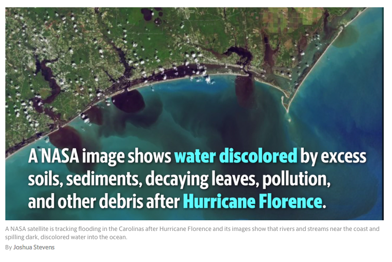
A NASA satellite is tracking flooding in the Carolinas following Hurricane Florence, and its images show dark, polluted water flowing from rivers into the Atlantic Ocean.
Nearly 8 trillion gallons of rain fell across North Carolina during the storm, according to the National Weather Service in Raleigh’s estimate.
That rain led to catastrophic flooding across the state, and has polluted rivers, streams creeks and their outflows along the coast, NASA’s satellite images show.
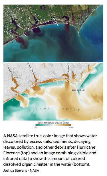
One image captured on Sept. 19 shows the New River, White Oak River and Adams Creek south of Cape Lookout, shows deeply discolored water that appears dark brown — or even black.
The color of the water in the image “reveals how soils, sediments, decaying leaves, pollution, and other debris have discolored the water in the swollen rivers, bays, estuaries, and the nearshore ocean,” according to NASA.
That soil, decaying plant matter, pollution and other debris is also referred to as “colored dissolved organic matter” or CDOM, according to NASA.
Another image from Sept. 19 shows how inundated the rivers, coast and much of the ocean around Cape Lookout are with the pollutants by coloring the affected water orange.
 “Organic matter—such as leaves, roots, or bark—contain pigments and chemicals (such as tannins) that can color the water when they dissolve. Depending on the amount of dissolved particles, the water in natural-color imagery can appear blue, green, yellow, or brown as the CDOM concentration increases,” NASA said.
“#HurricaneFlorence brought a surge of new water to North Carolina. Streams overflow with colored dissolved organic matter (CDOM) as carbon moves from land to sea. The dark plumes shooting into the Atlantic were seen by Landsat 8 two days ago,” Joshua Stevens, NASA data visualizer and cartographer, tweeted on Sept. 21.
Some amount of that organic matter, or “tannins” and sediment are normal in Carolina waterways and is why many streams and rivers appear yellow, green or brown.
But when there is more of that organic matter in waterways during or after major flood events, can become a pollutant, leading to reduced water quality and potentially harming wildlife.
This discoloration of Carolina waters from various pollutants has been seen in the wake of previous storms, and can lead to mass fish kills and other environmental effects, North Carolina scientists say.
North Carolina researchers are linking hurricanes like Florence and Matthew to long-term effects of this discolored water to the deaths of aquatic life and water quality that can be unsafe for humans.
UNC scientist Hans Paerl, N.C. State University scientist Christopher Osburn and their team are studying the flow of the water, largely discolored by organic matter such as leaves, straw, manure, wood, food-processing waste and other pollutants into North Carolina waterways following hurricanes.
The scientists are using the Neuse River as their area of study, analyzing “the flow of nutrients into the Neuse estuary and the sound, since excessive organic matter can pollute waters and damage ecosystems by killing off fish and other organisms,” The News & Observer previously reported.
As floodwaters from major storms move downstream, they carry those pollutants, which can create “dead zones” or areas where fish and other animals can’t live.
“In the discharges after hurricanes Floyd and Matthew, these dead zones grew large enough to affect shellfish and finfish habitats for miles,” Paerl previously told the N&O. “Fish kills lasted for months.”
